Created and maintained by volunteers working with the British Horse Society

RideMaps
MapMyHack Project2026 DobbinData DobbinDirect
Rides and Trails in England, Scotland, Wales and Northern Ireland
BHS Ridemaps provides a map of riding routes intended to inspire you to explore new country with your horse.
The BHS is not responsible for the current availability or condition of the routes or your safety while using them.
- Information given was accurate at publication but you should check locally where practicable.
- Ridemaps website is provided and maintained by British Horse Society volunteers.
- You are recommended to check before riding whether a route is still feasible. Lack of highway authority funding means that some may be neglected and may have changed in character since the route was first included.
- Many Rides include sections of road and/or road crossings. When planning your ride, you should consider whether these conditions will be safe for the horse you will be riding.
- For your safety when riding out, please see BHS advice on 'Responsible Riding', 'Hacking' and 'Hill and Upland Riding' on www.bhs.org.uk/accessadvice.
WAIT MAP IS LOADING
On the map to the left:
- Zoom using the controls or zoom to place using the box provided.
- Grab with mouse to move the map.
- Click on a Marker to
see Details of Rides in area.
 Single Rides
 Ride and Drive
 Multiple Rides
 Long Distance Rides
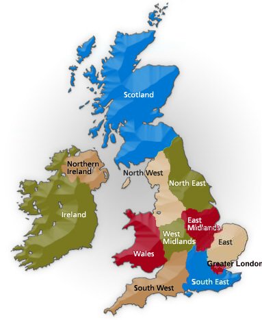
OR List and Display Rides near to you
OR on the map below:
- Click on a region to see rides in a region.